|
MapCatalog | Order | Support | SiteIndex | Contact | Home | ||||||||||
|
|
|
|
|
|
||||||||||||
| Web Maps | Download | License | Showcase | Reviews | ||||||||||||


|
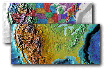
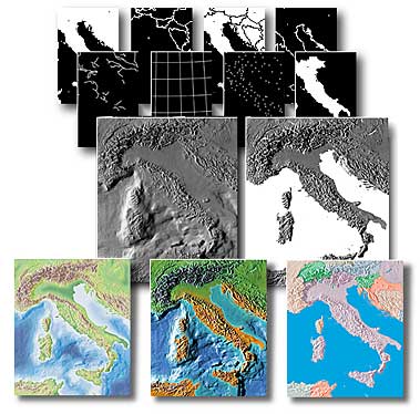
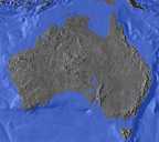
MOUNTAIN HIGH WEB MAPS is a unique collection of relief images of the world, continents, countries, and ocean floors. Each dimension and contour of our splendid planet is portrayed in a detailed and accurate topographical relief view. These images can be used to lend a fascinating realism to your web or multimedia projects, and help you to get your message across, navigate your web site, or simply show your clients your areas of interest or operation. Many successful titles featuring MOUNTAIN HIGH WEB MAPS include Where in the World is Carmen Sandiego, Tom Clancy SSN, CNN Time Capsule, AccuWeather and WeatherLabs, Arab Net, Intelsat, The Oregon Trail, Corbus Volcanoes, Quokka Sports and Wired.
The ultimate map making resourceMOUNTAIN HIGH WEB MAPS is published on a CD-ROM for both Windows and Macintosh computers. The CD-ROM contains 78 maps, available in three colorized formats - physical elevation, physical vegetation, political, and in two grayscale styles, with and without ocean floors. Each map portfolio comes complete with country outline masks, coastlines, borders, rivers, cities, and lines of latitude and longitude, all in JPEG mask format. In addition to the flat perspective maps, the collection includes spectacular perspectives of the globe in grayscale(with land/ocean masks) and colorized versions. These include regional centered views from high-interest areas of the world, global versions from strategic points, plus perspectives which are centered on major locations such as the US, Europe, Middle East, Far East and many other focal points. A set of 24 animated revolving globes are also included for you to use in your multimedia projects or as a GIF animation image resource. Flexible applicationsThe maps are presented as screen resolution map images for use with web or multimedia applications. MOUNTAIN HIGH WEB MAPS are provided in colorized formats and grayscale images, giving you the ability to apply your choice of colors through a wide range of the most popular DTP applications. The colorized and grayscale maps are in the industry standard JPEG format, and can be used by most paint, draw, and page layout applications, and web page development applications. We strongly recommend Adobe Photoshop as the ideal application environment for the image manipulation of MOUNTAIN HIGH WEB MAPS and have developed an extensive and detailed User Guide for almost all procedures.
A new world for your mapsMOUNTAIN HIGH WEB MAPS is a unique and uncomplicated way to dramatically enhance your web and multimedia map presentations. Used as backgrounds for your artwork and data, these maps will give your images a new authority and impact, whether your needs are for the highest level of professional multimedia or web authoring. Reproduction rights granted with your purchase of MOUNTAIN HIGH WEB MAPS allow internal use and, with free registration, most commercial uses without further payment of fees - MOUNTAIN HIGH WEB MAPS can be freely used subject to the conditions of the License Agreement and the Web and MultiMedia Guidelines. Award winning productMOUNTAIN HIGH WEB MAPS was honored with the 1996 MacUser Editors' Choice "EDDY" Award for "Best New Graphics Resource". Digital Wisdom was presented with this prestigious award in San Francisco Macworld Expo in January by MacUser magazine's editor-in-chief, Pamela Pfiffner. The MOUNTAIN HIGH WEB MAPS collection contains:

The JPEG images are best used with image-editing applications such as Adobe Photoshop but they can also be used within page layout and drawing applications, where color can be applied directly.
Files sizesThe map and globe images comprise an uncompressed file size of approximately 300 Mbytes. The grayscale screen resolution maps range from 100 Kbytes, averaging around 5 Mb grayscale and colorized maps between 10 to 50 Kb in RGB. Individual map images differ in size, averaging around 600 to 800 pixels in height and width; the largest world map is sized at 1,200 x 800 pixels. Issues relating to the quality and size of images are covered in Frequently Asked Questions page. Map scalesHorizontal scales range from 1:250,000 up to 1:45,000,000, giving on the ground pixel resolution varying from 1,000 metres to 50 km. Typical resolution for European countries is 500 to 2,000 metres per pixel, for US 1,000 to 4,000 metres per pixel, continental views range from 12 km to 24 km. Vertical scales range from 1:50,000 to 1:1,000,000, with contour intervals varying from 50 to 1,000 feet. To emphasize relief, the elevation scales have been exaggerated 5 to 30 times. The maps use many projection systems including Mercator, Gall, Lambert's equal-area, conformal conic, simple conic and zenithal. Political accuracyMOUNTAIN HIGH WEB MAPS Version 4.0 has been revised for all known and ratified political border decisions - updates can be downloaded on request by registered users from this web site. The regulating authorities whose advice has been sought in the preparation of the MOUNTAIN HIGH WEB MAPS material are the Office of the Geographer at the US Department of State, Washington DC and the International Boundaries Research Unit (IBRU) at the University of Durham in England. |
Any comments or problems with this
site? Please
let us know
- thank you!
© Digital Wisdom, Inc.